Neighbourhoods and crisis
Barris i Crisi means neighbourhoods and crisis in Catalan and is an university project which tries to answer two main aims: Analyse the impact of the crisis on social and spatial inequalities in Catalonian municipalities and their effects on the most disadvantaged neighbourhoods. And secondly, identify responses to this situation by the own neighbourhoods and understand the elements which contribute to the resilience of the communities to the crisis.
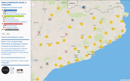
Part of the project is a map on social innovation showing initiatives which have both historical and also contemporary importance. The different examples are classified with the following categories:
- Citizen Solidarity (Time banking, movements against eviction)
- Territory, environment and energy (Urban gardening and alternative energy)
- Community telecommunication networks
- Alternative economies and consume (Social finances and consume groups)
- Self-managed spaces
The map was done using Leaflet map styling, Mapbox as map provider and custom JavaScript for filtering the categories. First I tried to read the data directly from Google Drive inspired by a script done by a citizen project mapping vacant houses. But this method is to slow as it actually has to read more than 600 registers. So for now I export the data from the spreadsheet and read it from a static GeoJSON file.
Tags: Barris i Crisi, barrisicrisi, crisis, crowdsourcing, geojson, IGOP, leafletjs, mapbox, mapping, UAB
