Posts Tagged ‘osm’

Customizable vector map for visual impaired ppl

Friday, March 14th, 2014

As part of my Bachelor Thesis I investigated accessibility for digital maps from the angle of visual impairment. Taking advantage of characteristics of vector maps, one of the results is a highly customizable map.

server
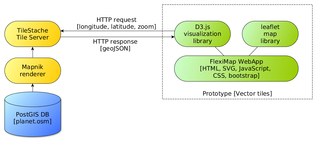
Instead of using pre (server) rendered raster images, the browser itself takes care of rendering vector data which represents the features in the tile. For example roads are sent as LineStrings, buildings, land and water as Polygons and POIs as Points. Javascript based on vector-osm converts them to SVG, the browser takes care of the rendering. Vector tiles are coming from Mapnik Vector Tiles in GeoJSON format using OpenStreetMap as data provider.

(more…)

Linz pflückt: Fruits for free

Sunday, May 26th, 2013

simple_leaf_xxhdpiLinz Pflückt shows more than 2000 public fruit trees in the city of Linz. The basic data comes from the open data portal which was launched as part of the Open Commons Region Linz. The dataset contains information on species, genus, tree height, etc. which we extended with information such as maturity and fruit category.

The fruits of the trees are freely available public domain, which may be picked and eaten by every person! Look at the trees and enjoy the taste of the fruits!

You as fruit fan are invited to evaluate the fruits, comment on the trees and to enrich them with photos. With your submissions, the project is gaining usability and usefulness.

Linz Pflückt is also available as app for Android devices. Owners of other phones can use the mobile version of the website.

The project was built using free software frameworks as OpenStreetMaps, leafletjs and WordPress.

Linz se declara región “Open Commons”

Thursday, August 5th, 2010

cclinz2s

La ciudad austriaca de Linz comienza -según ella- una iniciativa única en Europa para el uso libre de datos digitales. El proyecto “Open Commons” fomenta, además del software libre, los contenidos, datos y medios para el uso y la distribución libre. La finalidad es, sobre todo, económica: reducir costes, evitar dependencias, fomentar la iniciativa propia, crear valor añadido y fortalecer la economía, aumentar la transparencia y establecer seguridad jurídica.
(more…)

OpenStreetMap con Drupal y WordPress

Wednesday, July 7th, 2010

casastristes sabadellHace poco mostré como utilizar OpenStreetMap a través de la librería de JavaScript Openlayers. Ahora miramos como incrustarlo dentro de gestores de contenidos como Drupal y WordPress.

(more…)

OpenStreetMap con Openlayers

Tuesday, May 18th, 2010

osmOpenStreetMap es cada vez más una potencial alternativa a Google Maps, sobre todo en proyectos que dan importancia al uso de licencias libres. En seguida mostraré el uso de OpenStreetMap en páginas estáticas, más adelante lo presentaré posibilidades de usarlo con WordPress y Drupal.

Openlayers es la forma más sencilla de incrustar mapas de OSM en una web estática cualquiera. Aquí mostraré una forma rápida y sencilla de enlazarlo con una API de locación geográfica.
(more…)

Mapeando ciclovías

Friday, January 15th, 2010

Masa Crítica, 2 de febrero 2010, Santiago de Chile

Masa Crítica, 2 de febrero 2010, Santiago de Chile

Empecé a trabajar con OpenStreetMap en septiembre cuando organizamos un mapping party con Iván Sánchez de OSM España. Estuve recorriendo las ciclovías de Barcelona para complementar el mapa de opencyclemap (aun falta).

Desde que vivo en Santiago de Chile empecé a mapear las ciclovías de esta ciudad. El estado del mapa de Santiago va mejorando de semana a semana pero las ciclovías aun están casi inexistentes. Estoy trabajando con JOSM y con GPSMid. Para facilitar el uso de GPSMid pueden bajarse el programa precompilado con el mapa de Santiago centro aquí (.jad y .jar).

A ver si al complementar las ciclovías tenemos una mejor herramienta para exigir mejoras para los ciclistas de Santiago.